


Chelsea Township Voting District, Butler County, Kansas
About
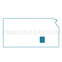
Outline

Summary
| Unique Area Identifier | 584114 |
| Name | Chelsea Township Voting District |
| County | Butler County |
| State | Kansas |
| Area (square miles) | 107.10 |
| Land Area (square miles) | 101.09 |
| Water Area (square miles) | 6.01 |
| % of Land Area | 94.39 |
| % of Water Area | 5.61 |
| Latitude of the Internal Point | 37.93486930 |
| Longtitude of the Internal Point | -96.66076810 |
Maps


Graphs
Select a template below for downloading or customizing gragh for Chelsea Township Voting District, Butler County, Kansas


Neighbors
Neighoring Voting District (by Name) Neighboring Voting District on the Map
- El Dorado Township Voting District, Butler County, KS
- Lincoln Township Voting District, Butler County, KS
- Prospect Township Voting District, Butler County, KS
- Salem Township Voting District, Greenwood County, KS
- South Salem Township C04 Voting District, Greenwood County, KS
- Sycamore/Cassoday Voting District, Butler County, KS
Top 10 Neighboring County Subdivision (by Population) Neighboring County Subdivision on the Map
- Prospect township, Butler County, KS (2,429)
- El Dorado township, Butler County, KS (1,039)
- Sycamore township, Butler County, KS (343)
- Lincoln township, Butler County, KS (310)
- Chelsea township, Butler County, KS (267)
- South Salem township, Greenwood County, KS (95)
- Salem township, Greenwood County, KS (33)
Top 10 Neighboring Unified School District (by Population) Neighboring Unified School District on the Map
- El Dorado Unified School District 490, KS (14,422)
- Eureka Unified School District 389, KS (4,508)
- Flinthills Unified School District 492, KS (1,429)
Top 10 Neighboring State Legislative District Lower Chamber (by Population) Neighboring State Legislative District Lower Chamber on the Map
- State House District 75, KS (21,740)
- State House District 70, KS (20,195)
- State House District 13, KS (17,996)